Puerto Vallarta is famous for its sun-drenched beaches, vibrant nightlife, and luxury resorts, but there’s so much more to explore beyond the typical tourist spots. Hiking in Puerto Vallarta offers the opportunity to experience nature at its finest, with hidden trails, waterfalls, and mountain vistas that most visitors miss. From the bustling Malecon to the peaceful Sierra Madre Mountains, this guide will take you through the best hiking trails in Puerto Vallarta, those that remain a well-kept secret to most tourists.
Whether you’re an experienced hiker or a beginner, Puerto Vallarta offers trails for all skill levels. The diverse landscape, from coastal hikes to jungle paths, provides breathtaking views of the Banderas Bay, hidden beaches, and verdant valleys. However, many of the best hiking experiences are tucked away, off the beaten path, and less crowded than the city’s popular tourist attractions.
Why Puerto Vallarta’s Hiking Trails Are a Must-Do for Adventurers
A Unique Blend of Coastal, Jungle, and Mountain Terrain
Puerto Vallarta’s landscape is one of the most diverse in all of Mexico. It’s not just the beaches that attract visitors; it’s the coastal, jungle, and mountain terrains that create a perfect environment for hiking. These varied landscapes mean that hikers can experience a variety of scenic views and wildlife, all within a few miles of the city.
- Coastal Trails: Puerto Vallarta’s beachfront trails allow hikers to stroll along the water’s edge, with the sound of the surf as the backdrop. Trails like Las Animas and Boca de Tomatlán offer the best of both worlds: ocean views and lush green forests.
- Jungle Hikes: Puerto Vallarta’s rainforests are full of unique flora and fauna. Trails like Monkey Mountain and Palo Maria Waterfall offer the chance to explore dense jungles and spot local wildlife, such as monkeys, iguanas, and tropical birds.
- Mountain Adventures: For a more challenging hike, the Sierra Madre Mountains provide steep ascents, panoramic views, and a chance to see hidden waterfalls. Trails like Mirador El Toro and Cerro de la Cruz will test your endurance while rewarding you with views that are nothing short of spectacular.
A Hiking Experience for All Skill Levels
One of the great things about hiking in Puerto Vallarta is that there are trails suitable for all levels of experience. Whether you’re looking for a leisurely walk along the beach or an intense jungle trek, there’s a hike for everyone.
- Beginner Trails: Simple coastal hikes like Las Animas Beach or Mirador La Cruz are perfect for newcomers. These easy hikes offer great views with relatively little effort.
- Intermediate Trails: For those who want more of a challenge, hikes like Monkey Mountain or El Salto Waterfall provide a more rugged experience, with some steep ascents and remote locations.
- Expert Trails: For seasoned hikers, the Sierra Madre Mountains offer some of the most challenging trails. Cerro El Toro and the Jungle Trails provide an opportunity to truly connect with nature while testing your skills.
Local Knowledge Enhances the Experience
Many of the best trails in Puerto Vallarta are off the beaten path, and local guides can help you find them. Guided tours provide valuable insights into the history, culture, and ecology of the area, making your hike even more enriching. Local guides also ensure your safety on more difficult trails and can help you spot wildlife that you might miss on your own. For those who prefer self-guided adventures, Puerto Vallarta’s local tourism offices offer maps and trail recommendations, ensuring you have all the information you need to explore safely.
Hidden Trails You Won’t Find on the Typical Tourist Map
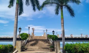
Mirador La Cruz: Puerto Vallarta’s Urban Lookout
Mirador La Cruz is an urban hike that’s often missed by tourists, but it offers one of the best views of Puerto Vallarta. The hike starts in the downtown area and takes you up to a lookout point with panoramic views of the city, Banderas Bay, and the Sierra Madre Mountains. While it’s located close to the city, this trail is often overlooked in favor of the beach. However, the rewarding vista from the top makes it a must-see for anyone wanting to take in the beauty of Puerto Vallarta from a higher vantage point.
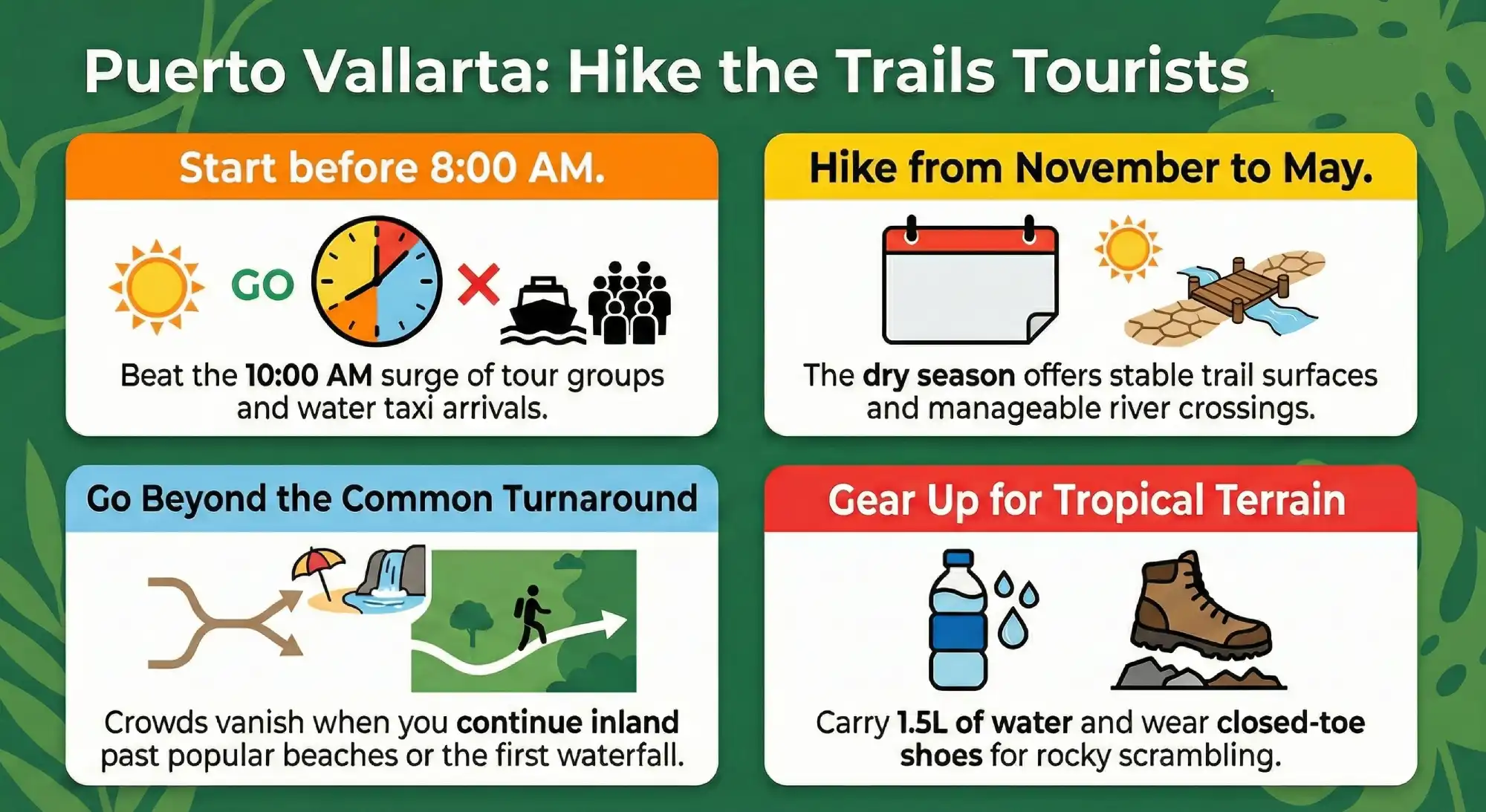
Pro Tip: Visit early in the morning or late afternoon to avoid the midday heat and capture stunning sunrise or sunset shots of the bay.
Monkey Mountain (Cerro de la Cruz): A Challenging Jungle Hike
Trail Overview: Monkey Mountain, or Cerro de la Cruz, is one of the most challenging hikes in Puerto Vallarta. The trail takes you through dense jungle, with steep sections leading to a summit that offers breathtaking views of the coastline and Banderas Bay. Unlike the typical beach hikes, Monkey Mountain offers a more rugged experience, with the opportunity to spot monkeys, birds, and other wildlife in the dense rainforest. The summit is a popular spot for panoramic photos.
Pro Tips: The hike is challenging, so be sure to wear sturdy shoes and bring plenty of water. If you’re not used to hiking in humid conditions, it’s a good idea to hire a local guide to make the trek safer and more enjoyable.
El Salto Waterfall & Jorullo Bridge: The Hidden Waterfall Trail
The Jorullo Bridge hike leads to the El Salto Waterfall, a hidden gem in Puerto Vallarta’s hinterlands. The trail is relatively remote, taking you through jungle paths and river crossings. The Jorullo Bridge is a spectacular sight, standing as one of the longest suspension bridges in Mexico. From here, visitors can access El Salto Waterfall, a natural wonder that is far less crowded than the city’s popular beach spots.
Pro Tip: The hike is best done during the wet season (May to October) when the waterfall is at its fullest and most spectacular.
Las Animas Beach Trail: The Coastal Path Less Traveled
The Las Animas Beach trail is a scenic, easy-to-moderate hike that runs from Boca de Tomatlán to Las Animas Beach. Whether you are planning a half-day snorkel trip or a sunset cruise, choosing the right boat rental in Puerto Vallarta is the first step toward an unforgettable vacation. This coastal route offers stunning views of the Pacific Ocean and passes through lush jungles and isolated beaches.
Many visitors miss this beautiful hike because they prefer more accessible or well-known spots, but this trail offers a peaceful alternative to the crowded beaches. It’s a great spot to enjoy the solitude and beauty of Puerto Vallarta’s coastline. The trail offers the chance to relax at Las Animas Beach, where you can swim, have a meal, or enjoy a quiet moment in nature before heading back.
Other Hidden Gems and Off-the-Beaten-Path Trails
Palo Maria Waterfall Trail: A Peaceful Escape
Palo Maria Waterfall is one of the more peaceful, hidden gems in Puerto Vallarta. The trail takes visitors through dense jungle to a stunning waterfall that’s perfect for swimming and relaxing in nature. This waterfall is relatively unexplored compared to other spots, making it an excellent choice for those looking to avoid the crowds and experience the natural beauty of the area in solitude.
Mirador El Toro: A Mountain Lookout Adventure
Mirador El Toro is a challenging mountain trail that takes hikers through lush jungle and up to one of the highest points in Puerto Vallarta. The summit offers spectacular panoramic views of the bay, mountains, and surrounding countryside. While many tourists stick to the main boardwalk, the most pristine waters are found at the best beaches in Puerto Vallarta, many of which are only accessible by water. Services along the inland section are limited.
Pro Tip: The hike is strenuous and should only be attempted by experienced hikers. Be sure to pack plenty of water and take your time.
Hidden Trail Comparison Overview
| Trail | Difficulty | Duration | Best Season | Ends at Beach? | Crowd Level |
| Boca to Colomitos (early start) | Moderate | 1–2 hrs | Nov–May | Yes | Low (early) |
| Palo Maria Upper Falls | Moderate | 1.5–2 hrs | Dec–May | No | Low |
| El Nogalito Eco Trail | Moderate | 2–3 hrs | Dry season | No | Very Low |
| Mirador de la Cruz (sunrise) | Moderate | 30–45 min | Year-round | No | Low (early) |
| Quimixto Inland Trail | Moderate | 2–3 hrs | Nov–May | Yes | Very Low |
What You Need to Know Before Hiking in Puerto Vallarta
Should You Hire a Guide?
Hiking in Puerto Vallarta can be an incredible experience, but the rugged trails and remote locations can make it tricky to explore without some local guidance. While some of the more popular trails like Mirador La Cruz are easy enough to navigate on your own, many of the hidden gems require expert knowledge to ensure safety and the best possible experience.
Benefits of Hiring a Guide
- Local Expertise: Local guides are well-versed in the landscape and weather conditions, ensuring you’re on the right trail and can navigate safely through challenging terrain, such as jungle trails and river crossings.
- Access to Hidden Spots: Some of the best trails are off the beaten path and not well-marked for tourists. A guide can take you to secret spots like El Salto Waterfall or Palo Maria Waterfall that are hard to find without insider knowledge.
- Safety: Puerto Vallarta’s natural beauty can also pose risks, wildlife, slippery paths, and sudden weather changes are all potential hazards. A guide ensures you’re properly prepared and can handle any unexpected challenges.
- Cultural Insights: Local guides often provide valuable information about the area’s cultural heritage, ecology, and wildlife, giving you a richer hiking experience.
When to Go Solo
Some shorter, easier trails like the Las Animas Beach hike or Mirador La Cruz can be tackled alone, but for longer and more remote hikes, such as Monkey Mountain or Yelapa Waterfall, a guide is highly recommended.
What to Wear and Bring for Hiking in Puerto Vallarta
When hiking in Puerto Vallarta, proper attire and preparation are key to a safe and enjoyable experience. The tropical climate, with its mix of heat and humidity, requires careful planning to ensure comfort throughout your hike. Coordinated departures from coastal areas can align well with marina-based services such as those operated by Palmara Charters, allowing hikers to transition from jungle terrain to open water comfortably.
Proper Footwear
- Hiking Boots: For rugged jungle trails, waterfall hikes, and mountain treks, a sturdy pair of hiking boots or trail shoes is essential. They provide ankle support and traction on uneven or slippery terrain.
- Waterproof Shoes: If your hike involves river crossings or a coastal trail, consider wearing waterproof shoes or water shoes that can handle wet conditions.
Clothing
- Light, Breathable Fabrics: Given Puerto Vallarta’s tropical climate, lightweight, moisture-wicking clothing is essential. Choose shorts and t-shirts made from fabrics like merino wool or synthetic blends to stay cool while wicking away sweat.
- Long-Sleeve Shirt and Pants: Even in warm weather, it’s a good idea to wear long sleeves and pants to protect against sunburn, insect bites, and scratches from jungle foliage.
Other Essentials
- Sun Protection: Apply high SPF sunscreen before the hike and reapply as needed. Sunglasses, a hat, and lip balm with SPF are essential for protecting your skin from the sun.
- Insect Repellent: Puerto Vallarta’s jungles and rivers are home to mosquitoes and other insects. Make sure to use bug repellent with DEET to protect yourself, especially in the rainy season.
- Water and Snacks: Bring plenty of water to stay hydrated, especially in the hot and humid conditions. Pack snacks like energy bars or fruit to keep your energy up during longer hikes.
Safety Checklist Before Attempting Lesser-Known Trails
Before starting any lesser-known hiking route around Puerto Vallarta, reviewing basic safety preparations can prevent unnecessary issues. Jungle and coastal terrain vary widely, and services are often limited once you leave main roads.
Pre-Hike Safety Checklist
- Carry at least 1–1.5 liters of water per person
- Wear closed-toe hiking shoes with grip
- Download offline maps in case of a limited signal
- Inform someone of your route and expected return time
- Avoid starting unfamiliar trails late in the afternoon
- Check local weather forecasts before departure
These measures may seem simple, but they significantly reduce risk. In remote areas, self-sufficiency matters more than convenience. The goal is not luxury for its own sake, but smarter energy management over the course of a full day outdoors. If you are traveling with a large group, a luxury catamaran charter provides the perfect balance of space, stability, and high-end amenities.
Frequently Asked Questions About Hiking in Puerto Vallarta
Is Puerto Vallarta good for hiking?
Yes, Puerto Vallarta offers a mix of coastal and jungle trails that suit moderate fitness levels. The surrounding Sierra Madre foothills provide elevation changes, river crossings, and scenic viewpoints. However, trails are less formalized than national parks in other countries, so preparation is important.
Are trails marked?
Most trails have limited or informal signage. While some routes are well known locally, clear directional markers are not always present. Using offline maps or local guidance helps reduce confusion at forks or river crossings.
Is hiking safe during rainy season?
Hiking is possible during the rainy season, but risks increase. Slippery rocks, mud, and sudden rainfall require caution. Avoid waterfall hikes immediately after heavy storms and monitor weather forecasts closely.
Do you need a guide?
For well-known routes, many hikers go independently. However, lesser-known inland trails may benefit from local guidance, especially if language barriers or navigation concerns exist.
Which trail is best for beginners?
Mirador de la Cruz, when started early, is often manageable for beginners due to its short duration. Coastal trails with gradual inclines are also suitable, provided hikers carry enough water and start early.
Travelling Suggestions: Who These Trails Are (and Aren’t) For
These hiking routes are best suited for active travelers who enjoy uneven terrain, humidity, and early starts. Individuals comfortable walking two to three hours with elevation changes will find these trails rewarding. They are not ideal for casual walkers expecting paved paths or structured facilities. Early risers benefit the most, as starting before peak heat significantly improves comfort.
Families with older children who have hiking experience may enjoy select routes, but planning becomes essential. Those preferring relaxed sightseeing may find coastal boat excursions or guided nature tours more suitable alternatives. Hiking in Puerto Vallarta rewards preparation and realistic expectations. When approached thoughtfully, these lesser-known trails offer a quieter view of the region beyond resort corridors and beachfront crowds.